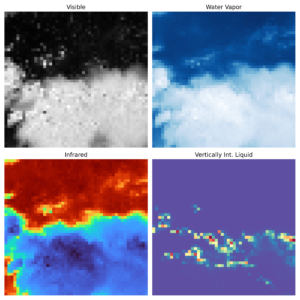
Dataset Details
sub-SEVIR
A subset of the Storm EVent ImagRy (SEVIR) dataset primed for machine learning meteorology tutorials.
Data Type
Remote sensing
Dataset Size
2 GB
File Type
Zarr
Time Range
2017 – 2019
Geographic Scope
Continental U.S.
Spatial Resolution
8 km
Time Resolution
5 minutes
Grid Size
48 x 48
Input Data Source
GOES-16 ABI and NEXRAD
Application / Use Case
Creating a machine learning model to determine what satellite/radar images contain lightning.
Dataset and/or GitHub URL
Point of Contact
Randy Chase; e-mail randychase [at] ou [dot] edu